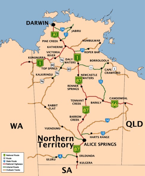
Northern Territory of Australia Road Network Maps
Home > Australian Maps > Northern Territory of Australia Road Maps
Northern Territory
The Northern Territory (NT) is a vast and sparsely populated region located in Australia's central and northern parts. It is bordered by Western Australia to the west, Queensland to the east, and South Australia to the south. The NT is known for its unique landscapes, rich Aboriginal culture, and diverse wildlife.
One of the most iconic features of the Northern Territory is its vast, rugged Outback. The region is characterized by vast stretches of arid desert, red sand dunes, and ancient rock formations. Uluru (Ayers Rock) and Kata Tjuta (The Olgas) in Uluru-Kata Tjuta National Park are internationally recognized natural landmarks and hold great cultural significance for the local Indigenous people. Visitors can explore these sites, witnessing stunning sunrises and sunsets over the imposing monoliths.
The NT is also home to Kakadu National Park, a UNESCO World Heritage site. Kakadu is renowned for its breathtaking natural beauty, with lush wetlands, rugged escarpments, and cascading waterfalls. The park is home to a rich variety of flora and fauna, including saltwater crocodiles, wallaroos, and a myriad of bird species. Visitors can take guided tours, go on wildlife cruises, and learn about Aboriginal rock art, which dates back thousands of years.
Aboriginal culture is deeply rooted in the Northern Territory, and visitors have the opportunity to learn about and appreciate the traditions and customs of the local Indigenous people. The Tiwi Islands, located off the coast of Darwin, are known for their vibrant Aboriginal art, cultural festivals, and welcoming communities. The Arnhem Land region in the northeast of the NT is renowned for its strong Indigenous culture and offers restricted access to preserve its natural and cultural heritage.
Darwin, the capital city of the Northern Territory, is a vibrant and cosmopolitan hub. It has a tropical climate and is known for its outdoor lifestyle, multicultural population, and colourful markets. The city offers a mix of modern amenities, including shopping centres, restaurants, and entertainment venues. The waterfront area, known as the Darwin Waterfront Precinct, is a popular spot for locals and tourists alike, with its lagoon, recreational facilities, and dining options.
The Northern Territory also hosts a variety of events and festivals that showcase its unique culture and natural surroundings. The Darwin Festival, held annually in August, celebrates the region's arts, music, and cultural diversity. The Henley-on-Todd Regatta, an unusual dry riverbed boat race held in Alice Springs, is a quirky and entertaining event that draws spectators from around the country.
Adventure and outdoor activities are a highlight of the NT. The region offers opportunities for bushwalking, camping, fishing, and exploring its remote and untouched wilderness. The Larapinta Trail in the West MacDonnell Ranges, a popular multi-day hiking trail, provides stunning vistas and a chance to experience the rugged beauty of the Outback.
In summary, the Northern Territory of Australia is a unique and diverse region known for its stunning natural landscapes, rich Aboriginal culture, and remote Outback experiences. From the iconic monolith of Uluru to the wetlands of Kakadu National Park and the vibrant city of Darwin, the NT offers an array of attractions and experiences that showcase Australia's northern frontier's beauty and cultural heritage.
Welcome to our Northern Territory of Australia road map page. The map of the Northern Territory of Australia that is located below is provided by Google Maps. You can "grab" the Northern Territory of Australia road map and move it around to re-centre the map. You can change between standard map view and satellite map view using the small square on the bottom left hand corner of the map. Satellite map view utilizes orbiting satellite or aerial high resolution photography to display images of the map location to street level detail (really quite amazing). Standard map view shows a traditional street map sometimes called a road map. You can use the zoom buttons on the bottom right hand side of the map to zoom in or out to street level detail. We have maps for most Australian towns and cities, so click on the Australian Maps link to see more Australian maps.
I hope you like the Northern Territory, NT, AU street map / road map situated above.
If you like our website, please consider adding a link to the site. These links help to build website traffic and they are considered a vote of confidence for a site.
City Maps
State Maps
Western Australia Road Network Map

From Wikipedia, the free encyclopaedia
Maps of the Northern Territory of Australia (NT)
A
B
C
D
E
F
G
H
I
J
K
L
M
N
O
P
Q
R
S
T
U
V
W
X
Y
Z
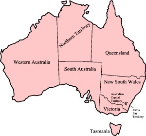
Map of Australian States and Territories


